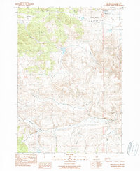
1990 Map of Frog Hollow
USGS Topo · Published 1990About this map
Caleb Cem sits as a quiet landmark within the high-desert landscape of central Oregon, where narrow valleys and seasonal drainages define the local topography. This 1990 provisional survey documents a network of canyons including Frog Hollow and Rhine Hollow, alongside grazing lands like Waterman Flat and Blann Meadow. The drainage patterns show a series of creeks flowing from the higher elevations, such as Whisky Creek, Spoon Mill Creek, and Keeton Creek, indicating the remote, resource-oriented nature of the Wheeler County interior. Industrial activity is sparsely represented by a Rock Quarry and a Gravel Pit, pointing toward the region's reliance on ranching and road maintenance. The map provides clear detail of the unimproved roads and trails that traverse this pocket of the state during the late twentieth century.
Find a feature on this map
23 named features on this map. Tap any name to fly to it.
Don’t see what you’re looking for? This feature index may not catch every label — zoom into the map to look around manually.
Map Details
Editions of this 1990 Frog Hollow Map
This is the sole edition of this map. No revisions or reprints were ever made.
Other maps of this area

1926 · Mitchell
USGS Topo · 1:125,000

1932 · Dayville
USGS Topo · 1:125,000

1936 · Dayville
USGS Topo · 1:125,000

1953 · Richmond
USGS Topo · 1:62,500

1955 · Bend
USGS Topo · 1:250,000

1955 · Canyon City
USGS Topo · 1:250,000

1957 · Bend
USGS Topo · 1:250,000

1958 · Bend
USGS Topo · 1:250,000

1959 · Canyon City
USGS Topo · 1:250,000

1966 · Peterson Point
USGS Topo · 1:24,000