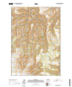
2020 Map of Johnson Heights
USGS Topo · Published 2020About this map
Johnson Heights sits atop the high ground of central Wheeler County, where the high-desert drainages of the Blue Mountains converge. The terrain is defined by a dense network of seasonal and perennial waters, including the creatively named Hide and Seek Cr and Yellow Jacket Cr. These creeks carve deep into the plateau, forming landmarks like Indian Hollow and Smith Hollow. The map reveals a land utilized for remote ranching and transit, centered on the Parrish Creek Rd corridor.
Find a feature on this map
23 named features on this map. Tap any name to fly to it.
Don’t see what you’re looking for? This feature index may not catch every label — zoom into the map to look around manually.
Map Details
Editions of this 2020 Johnson Heights Map
This is the sole edition of this map. No revisions or reprints were ever made.
Other maps of this area

1953 · Richmond
USGS Topo · 1:62,500

1953 · Kimberly
USGS Topo · 1:62,500

1953 · Picture
USGS Topo · 1:62,500

1953 · Spray
USGS Topo · 1:62,500

1955 · Canyon City
USGS Topo · 1:250,000

1959 · Canyon City
USGS Topo · 1:250,000

1980 · Monument
USGS Topo · 1:100,000
1990 · Tubb Spring
USGS Topo · 1:24,000
1990 · Picture Gorge West
USGS Topo · 1:24,000
1990 · Frog Hollow
USGS Topo · 1:24,000