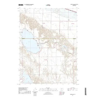
2017 Map of Johnson Lake
USGS Topo · Published 2017About this map
Johnson Lake anchors this Central Nebraska landscape, straddling the border between Dawson and Gosper counties. This water management system is defined by the Tri County Supply Canal and a series of smaller impoundments, including Elwood Reservoir, Knoeizer Reservoir, and Canby Reservoir. The map reveals a developed recreational and residential shoreline, particularly at Mallard Beach and North Shore, where numerous bays and points like Mallard Cove and Kilby Point articulate the lake's perimeter. To the north, the Platte River flows past Danielson Island, while the surrounding terrain is etched by drainage features such as Plum Cr. The inclusion of the Johnson Lake Airport and a dense network of local roads like Elwood Lake Dr indicates the area's role as a regional hub for water-based activity and transit.
Find a feature on this map
45 named features on this map. Tap any name to fly to it.
Don’t see what you’re looking for? This feature index may not catch every label — zoom into the map to look around manually.
Map Details
Editions of this 2017 Johnson Lake Map
This is the sole edition of this map. No revisions or reprints were ever made.
Other maps of this area

1896 · Lexington
USGS Topo · 1:125,000

1899 · Lexington
USGS Topo · 1:125,000

1955 · Grand Island
USGS Topo · 1:250,000

1957 · Grand Island
USGS Topo · 1:250,000

1958 · Grand Island
USGS Topo · 1:250,000

1962 · Lexington West
USGS Topo · 1:24,000

1962 · Lexington East
USGS Topo · 1:24,000

1962 · Bertrand NW
USGS Topo · 1:24,000
1971 · Johnson Lake
USGS Topo · 1:24,000
1971 · Elwood SW
USGS Topo · 1:24,000