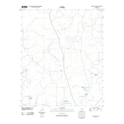
2010 Map of Johnson Lake
USGS Topo · Published 2010About this map
The West Fork Trinity River and its numerous tributaries, including Jones Creek, Crooked Creek, and Flag Springs Creek, define the landscape of this Jack County territory. The area is characterized by a complex network of mid-century water management infrastructure, evidenced by the Worthington Lake system and several Soil Conservation Service projects like the Soil Conservation Service Site 18 Reservoir. For those researching local family history, the map preserves the location of rural landmarks such as Brown Cemetery in the northeast and Patton Cemetery near the center. The road network, featuring routes like Lindsey Ranch Rd and Old Post Oak Rd, reflects a ranching and rural residential layout that has persisted through the early 21st century.
Find a feature on this map
38 named features on this map. Tap any name to fly to it.
Don’t see what you’re looking for? This feature index may not catch every label — zoom into the map to look around manually.
Map Details
Editions of this 2010 Johnson Lake Map
This is the sole edition of this map. No revisions or reprints were ever made.
Other maps of this area

1954 · Wichita Falls
USGS Topo · 1:250,000

1958 · Wichita Falls
USGS Topo · 1:250,000

1960 · Jacksboro
USGS Topo · 1:24,000

1961 · Jacksboro NE
USGS Topo · 1:24,000

1962 · Antelope Creek NE
USGS Topo · 1:24,000

1964 · Senate
USGS Topo · 1:24,000

1964 · Cundiff
USGS Topo · 1:24,000

1964 · Johnson Lake
USGS Topo · 1:24,000

1964 · Lynn Creek
USGS Topo · 1:24,000
1964 · Newport
USGS Topo · 1:24,000