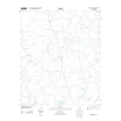
2012 Map of Johnson Lake
USGS Topo · Published 2012About this map
The W Fork Trinity River winds through this northern Jack County landscape, defining a terrain shaped by various tributaries and managed water resources. Local family history is centered around quiet landmarks such as Brown Cem and Patton Cem, while the area's agricultural and conservation history is evident in features like the Soil Conservation Service Site 21 Reservoir and several named catchments including Johnson Lake and the series of Worthington Lakes.
Find a feature on this map
35 named features on this map. Tap any name to fly to it.
Don’t see what you’re looking for? This feature index may not catch every label — zoom into the map to look around manually.
Map Details
Editions of this 2012 Johnson Lake Map
This is the sole edition of this map. No revisions or reprints were ever made.
Other maps of this area

1954 · Wichita Falls
USGS Topo · 1:250,000

1958 · Wichita Falls
USGS Topo · 1:250,000

1960 · Jacksboro
USGS Topo · 1:24,000

1961 · Jacksboro NE
USGS Topo · 1:24,000

1962 · Antelope Creek NE
USGS Topo · 1:24,000

1964 · Senate
USGS Topo · 1:24,000

1964 · Cundiff
USGS Topo · 1:24,000

1964 · Johnson Lake
USGS Topo · 1:24,000

1964 · Lynn Creek
USGS Topo · 1:24,000
1964 · Newport
USGS Topo · 1:24,000