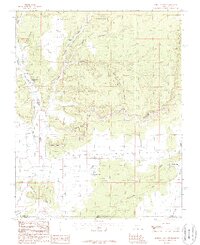
1987 Map of Johnson Lakes
USGS Topo · Published 1987About this map
The high desert plateaus and deeply incised canyons of Kane County, Utah, dominate this late-twentieth-century study of the Utah-Arizona borderlands. The settlement of Johnson serves as the primary human landmark in a landscape defined by dramatic geological features like Wygaret Terrace and the towering Vermilion Cliffs. The drainage patterns are meticulously recorded, showing how seasonal flows have carved the Johnson Canyon and Center Canyon, eventually feeding into the Johnson Lakes area.
Find a feature on this map
37 named features on this map. Tap any name to fly to it.
Don’t see what you’re looking for? This feature index may not catch every label — zoom into the map to look around manually.
Map Details
Editions of this 1987 Johnson Lakes Map
This is the sole edition of this map. No revisions or reprints were ever made.
Other maps of this area

1886 · Kanab
USGS Topo · 1:250,000

1886 · Kaibab
USGS Topo · 1:250,000

1953 · Cedar City
USGS Topo · 1:250,000

1953 · Grand Canyon
USGS Topo · 1:250,000

1954 · Buckskin Gulch NW
USGS Topo · 1:24,000

1954 · Buckskin Gulch SW
USGS Topo · 1:24,000

1954 · Johnson SE
USGS Topo · 1:24,000

1954 · Johnson NE
USGS Topo · 1:24,000

1954 · Shinarump NW
USGS Topo · 1:24,000

1954 · Johnson SW
USGS Topo · 1:24,000