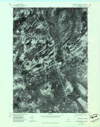
1979 Map of Johnson Mountain
USGS Topo · Published 1983About this map
West Forks and the surrounding wilderness of Somerset County are captured in this 1979 orthophotograph, which uses aerial imagery to reveal the textured timberlands and water systems of the Maine North Woods. The namesake Johnson Mountain dominates the western portion of the quadrangle, characterized by its complex ridge patterns and the scattered Mountain Ponds. The drainage of this upland terrain is clearly visible through the winding course of Cold Stream and the East Branch Salmon Stream, which cut through the dense forest cover. This photographic record provides a literal view of the logging roads and natural clearings during the late twentieth century, showing the land exactly as it was captured by the camera before modern satellite imagery became the standard for topographic recording.
Find a feature on this map
5 named features on this map. Tap any name to fly to it.
Don’t see what you’re looking for? This feature index may not catch every label — zoom into the map to look around manually.
Map Details
Editions of this 1979 Johnson Mountain Map
This is the sole edition of this map. No revisions or reprints were ever made.
Other maps of this area

1905 · The Forks
USGS Topo · 1:62,500

1907 · The Forks
USGS Topo · 1:62,500

1921 · Brassua Lake
USGS Topo · 1:62,500

1922 · Long Pond
USGS Topo · 1:62,500

1923 · Brassua Lake
USGS Topo · 1:62,500

1924 · Long Pond
USGS Topo · 1:62,500

1925 · Pierce Pond
USGS Topo · 1:48,000

1927 · Pierce Pond
USGS Topo · 1:62,500

1944 · Brassua Lake
USGS Topo · 1:62,500

1944 · Long Pond
USGS Topo · 1:62,500
Featured Places
- West Forks, ME
- Upper Enchanted Township, ME
- Johnson Mountain Township, ME
- Chase Stream Township, ME
- Lower Enchanted Township, ME