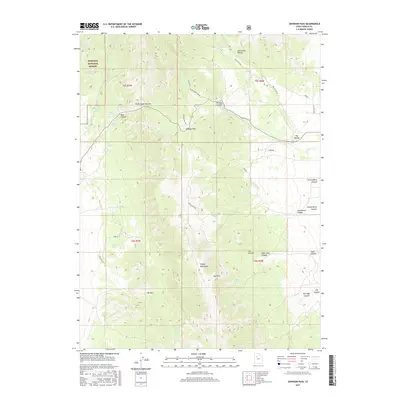
2017 Map of Johnson Pass
USGS Topo · Published 2017About this map
The Onaqui Mountains anchor this high-altitude landscape in Tooele County, where the historic route through Johnson Pass separates the northern and southern ridges. This topographic study illuminates a region defined by complex drainage systems and isolated watering points, such as Stookey Springs, Caldwell Spring, and Willow Springs, which have long been vital in this arid environment. The map details a network of canyons, including Saint Jeor Canyon and Vickory Canyon, that cut through the terrain toward the lower elevations of The Dell. Within the Wasatch National Forest boundary, the terrain becomes particularly constricted at Devils Gate Narrows. Modern access is traced via Valley View Dr and Vickory Mountain Rd, showing how contemporary infrastructure follows the natural corridors of the Great Basin peaks.
Find a feature on this map
44 named features on this map. Tap any name to fly to it.
Don’t see what you’re looking for? This feature index may not catch every label — zoom into the map to look around manually.
Map Details
Editions of this 2017 Johnson Pass Map
This is the sole edition of this map. No revisions or reprints were ever made.
Other maps of this area

1885 · Tooele Valley
USGS Topo · 1:250,000

1918 · Stockton
USGS Topo · 1:62,500

1953 · Tooele
USGS Topo · 1:250,000

1955 · Davis Knolls
USGS Topo · 1:24,000

1955 · Deseret Peak
USGS Topo · 1:62,500

1955 · Stockton
USGS Topo · 1:62,500

1955 · Tooele
USGS Topo · 1:250,000
1971 · Faust
USGS Topo · 1:24,000

1971 · Onaqui Mts South
USGS Topo · 1:24,000

1979 · Rush Valley
USGS Topo · 1:100,000