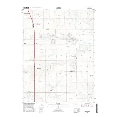
2016 Map of Johnstown
USGS Topo · Published 2016About this map
Johnstown and Berthoud anchor this landscape along the border of Larimer and Weld counties, where a sophisticated network of irrigation sustains the agricultural plains. The map reveals an intricate system of water management including the Hillsboro Ditch, Home Supply Ditch, and Farmers Extension Canal, which draw from the Big Thompson River and Little Thompson River. These waterways feed numerous storage bodies like Johnstown Reservoir, Isabel Myron Reservoir, and Hartford Reservoir. Smaller settlements and sidings such as Elwell, Buda, and Wildcat are scattered throughout the quadrangle, reflecting the rural development of the Northern Front Range. The Elwell Cem and various named reservoirs provide specific points of interest for genealogists and local historians tracing family land holdings and historical water rights in this irrigation-dependent region.
Find a feature on this map
110 named features on this map. Tap any name to fly to it.
Don’t see what you’re looking for? This feature index may not catch every label — zoom into the map to look around manually.
Map Details
Editions of this 2016 Johnstown Map
This is the sole edition of this map. No revisions or reprints were ever made.
Other maps of this area

1902 · Greeley
USGS Topo · 1:125,000

1904 · Niwot
USGS Topo · 1:62,500

1906 · Loveland
USGS Topo · 1:62,500

1908 · Loveland
USGS Topo · 1:62,500

1949 · Gowanda
USGS Topo · 1:24,000

1949 · Platteville
USGS Topo · 1:24,000

1950 · Gowanda
USGS Topo · 1:24,000

1950 · Platteville
USGS Topo · 1:24,000

1950 · Windsor
USGS Topo · 1:24,000
1950 · Longmont
USGS Topo · 1:24,000