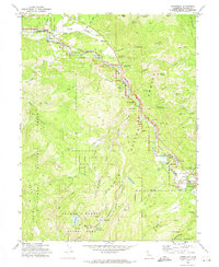
1972 Map of Johnsville
USGS Topo · Published 1974About this map
The Middle Fork Feather River carves through this Plumas County landscape, following the path of the Western Pacific railroad through Mohawk Valley. This 1972 field-checked record reveals a region transitioning from its hard-rock mining roots to a recreational destination. The historic core of Johnsville serves as a gateway to Plumas Eureka State Park, where the industrial history of the Sierra Nevada is preserved in the Mammoth Mill (Ruins), the Mammoth Tunnel, and the Plumas Eureka Mill (Tunnel). Evidence of earlier timber and mining operations is scattered across the terrain, from the Knickrem Mill (Site) on Squirrel Creek to the Squirrel Creek Mine. Small settlements like Sloat, Cromberg, and Graeagle dot the rail line and valley floor, while the Feather River Prep Sch and nearby golf courses reflect the mid-century growth of seasonal tourism and residential development.
Find a feature on this map
52 named features on this map. Tap any name to fly to it.
Don’t see what you’re looking for? This feature index may not catch every label — zoom into the map to look around manually.
Map Details
Editions of this 1972 Johnsville Map
This is the sole edition of this map. No revisions or reprints were ever made.
Other maps of this area

1891 · Downieville
USGS Topo · 1:125,000

1893 · Downieville
USGS Topo · 1:125,000

1895 · Downieville
USGS Topo · 1:125,000

1896 · Downieville
USGS Topo · 1:125,000

1897 · Downieville
USGS Topo · 1:125,000

1937 · Blairsden
USGS Topo · 1:48,000

1943 · Blairsden
USGS Topo · 1:62,500
1950 · Spring Garden
USGS Topo · 1:24,000
1951 · Mt. Fillmore
USGS Topo · 1:24,000
1951 · Blue Nose Mtn
USGS Topo · 1:24,000