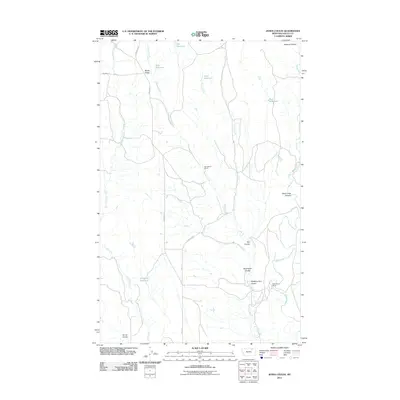
2011 Map of Jones Coulee
USGS Topo · Published 2011About this map
Ratchford's Ranch serves as a central landmark in this high-plains landscape of Valley County, Montana, where a complex network of coulees and intermittent water sources defines the terrain. The presence of multiple man-made water catchments, including Erie Reservoir, York Reservoir, and Swift Reservoir, highlights the vital importance of water management in this cattle-grazing region. These reservoirs sit along the upper reaches of Papoose Creek and Jones Coulee, north of where the land drops toward the distinct Rock Creek Canyon.
Find a feature on this map
22 named features on this map. Tap any name to fly to it.
Don’t see what you’re looking for? This feature index may not catch every label — zoom into the map to look around manually.
Map Details
Editions of this 2011 Jones Coulee Map
This is the sole edition of this map. No revisions or reprints were ever made.
Other maps of this area

1906 · Hinsdale Special Map
USGS Topo · 1:62,500

1919 · Boundary
USGS Topo · 1:125,000

1943 · Glasgow
USGS Topo · 1:125,000

1954 · Glasgow
USGS Topo · 1:250,000

1957 · Glasgow
USGS Topo · 1:250,000

1958 · Glasgow
USGS Topo · 1:250,000

1969 · Ellsworth Coulee
USGS Topo · 1:24,000

1984 · Bjornberg Bridge
USGS Topo · 1:24,000

1984 · Opheim
USGS Topo · 1:100,000
1984 · Jones Coulee
USGS Topo · 1:24,000