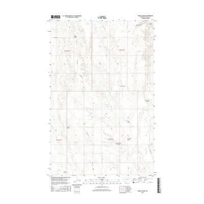
2017 Map of Jones Coulee
USGS Topo · Published 2017About this map
Erie Reservoir and York Reservoir sit atop the high prairie of northern Valley County, marking a landscape defined by cattle ranching and water management. This area of Montana is characterized by a series of deep drainage channels known as coulees that cut through the terrain toward larger water systems. Notable landmarks like Windy Ridge and the winding Rock Creek Canyon provide topographic relief in a region dominated by wide-open grazing lands. The distribution of features such as Sheepherders Coulee and Norwegian Coulee reflects the heritage of early livestock operations and the cultural history of the homesteaders who worked this arid section of the Missouri River watershed. Critical infrastructure like Hinsdale N Rd and Keilman Rd provides the primary access through these townships, connecting isolated reservoirs including Swift Reservoir and Florence Reservoir.
Find a feature on this map
26 named features on this map. Tap any name to fly to it.
Don’t see what you’re looking for? This feature index may not catch every label — zoom into the map to look around manually.
Map Details
Editions of this 2017 Jones Coulee Map
This is the sole edition of this map. No revisions or reprints were ever made.
Other maps of this area

1906 · Hinsdale Special Map
USGS Topo · 1:62,500

1919 · Boundary
USGS Topo · 1:125,000

1943 · Glasgow
USGS Topo · 1:125,000

1954 · Glasgow
USGS Topo · 1:250,000

1957 · Glasgow
USGS Topo · 1:250,000

1958 · Glasgow
USGS Topo · 1:250,000

1969 · Ellsworth Coulee
USGS Topo · 1:24,000

1984 · Bjornberg Bridge
USGS Topo · 1:24,000

1984 · Opheim
USGS Topo · 1:100,000
1984 · Jones Coulee
USGS Topo · 1:24,000