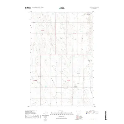
2020 Map of Jones Coulee
USGS Topo · Published 2020About this map
Erie Reservoir and York Reservoir sit at the northern edge of this high-plains landscape, where seasonal drainages have carved a complex network of coulees through the terrain. The presence of several artificial water bodies, including Swift Reservoir and Bud Reservoir, suggests a landscape carefully managed for livestock grazing and water conservation. This region of Valley County is defined by its dramatic relief, most notably at Rock Creek Canyon and along the prominent Windy Ridge. Cultural history is reflected in the naming of the landscape, from the work-oriented Sheepherders Coulee to the heritage-driven Norwegian Coulee. Ranching infrastructure is further evidenced by routes like Hinsdale N Rd and Rte 537, which connect these dispersed water sources and coulee pastures.
Find a feature on this map
27 named features on this map. Tap any name to fly to it.
Don’t see what you’re looking for? This feature index may not catch every label — zoom into the map to look around manually.
Map Details
Editions of this 2020 Jones Coulee Map
This is the sole edition of this map. No revisions or reprints were ever made.
Other maps of this area

1906 · Hinsdale Special Map
USGS Topo · 1:62,500

1919 · Boundary
USGS Topo · 1:125,000

1943 · Glasgow
USGS Topo · 1:125,000

1954 · Glasgow
USGS Topo · 1:250,000

1957 · Glasgow
USGS Topo · 1:250,000

1958 · Glasgow
USGS Topo · 1:250,000

1969 · Ellsworth Coulee
USGS Topo · 1:24,000

1984 · Bjornberg Bridge
USGS Topo · 1:24,000

1984 · Opheim
USGS Topo · 1:100,000
1984 · Jones Coulee
USGS Topo · 1:24,000