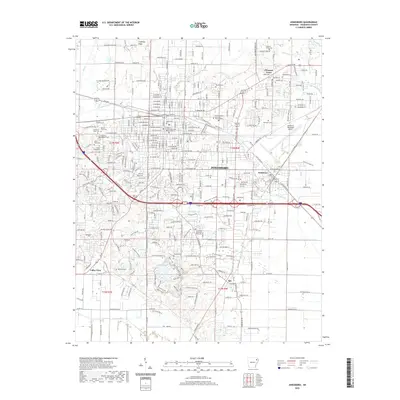
2020 Map of Jonesboro
USGS Topo · Published 2020About this map
Jonesboro sits at a critical geographic junction where the elevated terrain of Crowleys Ridge meets the alluvial plains of the Arkansas Delta. This 2020 layout reveals the expansion of the Arkansas State University - Main Campus and the integration of formerly distinct communities like Nettleton. The map captures the dense street grid surrounding the Craighead County Courthouse - Western District, extending outward toward newer developments near Valley View. Historically significant sites, such as the Woodlawn Oaklawn Cem and the Mount Sinai Cem Temple of Israel Cem, reflect the city's long-standing cultural and religious heritage. The drainage patterns of Lost Cr Ditch and Higginbottom Cr illustrate the managed water systems necessary for this landscape, while the BNSF Railway continues to mark the industrial corridor that spurred early growth.
Find a feature on this map
199 named features on this map. Tap any name to fly to it.
Don’t see what you’re looking for? This feature index may not catch every label — zoom into the map to look around manually.
Map Details
Editions of this 2020 Jonesboro Map
This is the sole edition of this map. No revisions or reprints were ever made.
Other maps of this area

1935 · Sedgwick
USGS Topo · 1:62,500

1939 · Weiner
USGS Topo · 1:62,500

1939 · Jonesboro
USGS Topo · 1:62,500

1940 · Dee
USGS Topo · 1:62,500

1953 · Memphis
USGS Topo · 1:250,000

1956 · Memphis
USGS Topo · 1:250,000

1958 · Dee
USGS Topo · 1:62,500

1958 · Jonesboro
USGS Topo · 1:62,500

1959 · Weiner
USGS Topo · 1:62,500

1959 · Sedgwick
USGS Topo · 1:62,500