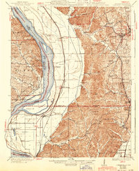
1923 Map of Jonesboro
USGS Topo · Published 1943About this map
The Mississippi River defines the western edge of this landscape, its shifting channel creating complex landforms like Devils Island and Edmondson Slough along the border between Missouri and Illinois. To the east, the topography transitions sharply into the rugged ridges of Shawnee, where the State Forest and a Fire Tower overlook a dense network of upland hollows and ridges like Atwood Ridge. The region's social fabric is visible in the numerous rural schoolhouses and country churches, such as St Pauls Church and Lockard Chapel, which served the scattered farming communities near Pottsville and Reynoldsville.
Find a feature on this map
89 named features on this map. Tap any name to fly to it.
Don’t see what you’re looking for? This feature index may not catch every label — zoom into the map to look around manually.
Map Details
Editions of this 1923 Jonesboro Map
2 editions found
Other maps of this area

1918 · Altenburg
USGS Topo · 1:62,500

1920 · Jonesboro
USGS Topo · 1:62,500

1920 · Dongola
USGS Topo · 1:62,500

1922 · Carbondale
USGS Topo · 1:62,500

1922 · Cape Girardeau
USGS Topo · 1:62,500

1923 · Dongola
USGS Topo · 1:62,500

1923 · Jonesboro
USGS Topo · 1:62,500

1924 · Cape Girardeau
USGS Topo · 1:62,500

1924 · Alto Pass
USGS Topo · 1:62,500

1925 · Altenburg
USGS Topo · 1:62,500