
1923 Map of Jonesboro
USGS Topo · Published 1923About this map
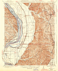
The Mississippi River creates a dynamic border between Illinois and Missouri, anchoring a landscape where the river’s alluvial plains meet the sharp relief of the Shawnee hills. In the early 1920s, the twin settlements of Jonesboro and Anna served as the regional hub, connected to the wider world via the Mobile and Ohio Railroad and the Illinois Central. The mapping reveals a dense network of rural education and faith, featuring numerous country schools like Lockard Chapel School and Big Barn School, alongside established congregations at Casper Church and Ebenezer Church. West of the bluffs, the bottomlands near McClure and East Cape Girardeau are defined by intricate waterways such as Clear Creek and Edmondson Slough, reflecting a precarious relationship with the shifting river channel and the seasonal flooding of Devils Island.
Find a feature on this map
81 named features on this map. Tap any name to fly to it.
Don’t see what you’re looking for? This feature index may not catch every label — zoom into the map to look around manually.
Map Details
Editions of this 1923 Jonesboro Map
2 editions found
Other maps of this area

1918 · Altenburg
USGS Topo · 1:62,500

1920 · Jonesboro
USGS Topo · 1:62,500

1920 · Dongola
USGS Topo · 1:62,500

1922 · Carbondale
USGS Topo · 1:62,500

1922 · Cape Girardeau
USGS Topo · 1:62,500

1923 · Dongola
USGS Topo · 1:62,500

1924 · Cape Girardeau
USGS Topo · 1:62,500

1924 · Alto Pass
USGS Topo · 1:62,500

1925 · Altenburg
USGS Topo · 1:62,500

1931 · Cairo
USGS Topo · 1:62,500