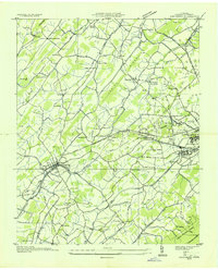
1935 Map of Jonesboro
USGS Topo · Published 1935About this map
The town of Jonesboro serves as the focal point of this mid-1930s survey, showing the established community along the Southern railroad line before modern highway expansion altered the rural landscape. To the northeast, the grounds of the Veterans Administration Mountain Home and the National Soldiers Home occupy a significant portion of the area adjacent to Johnson City. The map documents a dense network of local education and faith, featuring numerous small institutions like the Columbia Institute, Matson Institute, and McKinley Sch, alongside country chapels such as Marvin Chapel and Snow Chapel. The topography is defined by the prominent Indian Ridge and the northern reaches of the Unaka National Forest near Cherokee Mountain. This study, compiled from aerial photographs by the Tennessee Valley Authority and the USGS, captures the transition of the Andrew Johnson Highway as it connected these eastern Tennessee valley settlements during the Depression era.
Find a feature on this map
66 named features on this map. Tap any name to fly to it.
Don’t see what you’re looking for? This feature index may not catch every label — zoom into the map to look around manually.
Map Details
Editions of this 1935 Jonesboro Map
This is the sole edition of this map. No revisions or reprints were ever made.
Other maps of this area

1891 · Roan Mountain
USGS Topo · 1:125,000

1892 · Greeneville
USGS Topo · 1:125,000

1894 · Roan Mountain
USGS Topo · 1:125,000

1896 · Greeneville
USGS Topo · 1:125,000

1904 · Roan Mountain
USGS Topo · 1:125,000

1904 · Greeneville
USGS Topo · 1:125,000

1935 · Sullivan Gardens
USGS Topo · 1:24,000

1935 · Leesburg
USGS Topo · 1:24,000

1935 · Erwin
USGS Topo · 1:24,000

1935 · Spurgeon
USGS Topo · 1:24,000