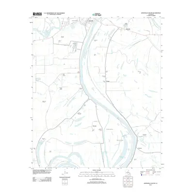
2012 Map of Jonesville South
USGS Topo · Published 2012About this map
The Black River serves as the central artery for this region south of Jonesville, where the floodplain landscape is defined by its complex network of sloughs and bayous. In this 2012 survey, the geography reveals a deep agricultural and industrial heritage, with land divided between expansive oil and gas fields and historic riverside holdings. Small settlements like Wildsville, Lismore, and Security are scattered along the levees, often marked by family and plantation cemeteries such as the Security Plantation Cem and Griffin Cem. The proliferation of extraction sites, including the Ross Bayou Gas Field and California Bayou Oil Field, highlights the area's modern economic reliance on energy resources. For genealogists, the map preserves numerous burial sites such as Elmly Cem, Calhoun Cem, and Wilkerson Cem, providing a precise record of local heritage sites nestled between the bends of Jones Bayou and the Tensas River.
Find a feature on this map
69 named features on this map. Tap any name to fly to it.
Don’t see what you’re looking for? This feature index may not catch every label — zoom into the map to look around manually.
Map Details
Editions of this 2012 Jonesville South Map
This is the sole edition of this map. No revisions or reprints were ever made.
Other maps of this area

1935 · Tooleys
USGS Topo · 1:62,500

1939 · Red Gum
USGS Topo · 1:62,500

1939 · Deer Park
USGS Topo · 1:62,500

1941 · Manifest
USGS Topo · 1:62,500

1941 · Tooleys
USGS Topo · 1:62,500

1953 · Natchez
USGS Topo · 1:250,000

1956 · Natchez
USGS Topo · 1:250,000

1959 · Natchez
USGS Topo · 1:250,000

1960 · Jonesville
USGS Topo · 1:62,500
1960 · Eva
USGS Topo · 1:62,500