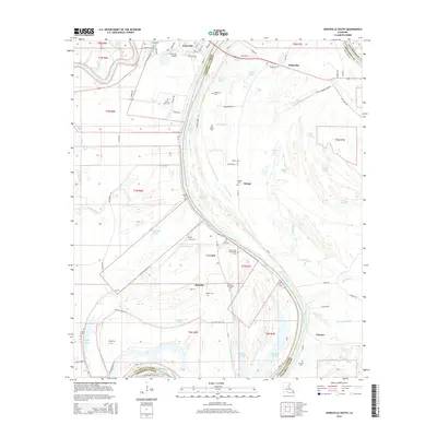
2015 Map of Jonesville South
USGS Topo · Published 2015About this map
The Black River and Little River converge at Jonesville, a significant navigational junction in the Louisiana delta country. This landscape is defined by its complex hydrology, where numerous bayous and sloughs like Fourmile Bayou and Gin Slough thread through the low-lying terrain. The map reveals a high density of rural cemeteries and plantation-affiliated burial grounds, including the Security Plantation Cem and Moss Grove Plantation Cem, which serve as vital markers of the region's agricultural and social history. Moving south from Jonesville, the small settlements of Security, Omega, and Lismore follow the natural levees and road networks like La-124, while the interior remains a mosaic of oxbow lakes such as Tronsel Lake and Snag Lake. This geography reflects a way of life deeply tied to the shifting river channels and the fertile, if flood-prone, alluvial soils of Catahoula and Concordia Parishes.
Find a feature on this map
95 named features on this map. Tap any name to fly to it.
Don’t see what you’re looking for? This feature index may not catch every label — zoom into the map to look around manually.
Map Details
Editions of this 2015 Jonesville South Map
This is the sole edition of this map. No revisions or reprints were ever made.
Other maps of this area

1935 · Tooleys
USGS Topo · 1:62,500

1939 · Red Gum
USGS Topo · 1:62,500

1939 · Deer Park
USGS Topo · 1:62,500

1941 · Manifest
USGS Topo · 1:62,500

1941 · Tooleys
USGS Topo · 1:62,500

1953 · Natchez
USGS Topo · 1:250,000

1956 · Natchez
USGS Topo · 1:250,000

1959 · Natchez
USGS Topo · 1:250,000

1960 · Jonesville
USGS Topo · 1:62,500
1960 · Eva
USGS Topo · 1:62,500