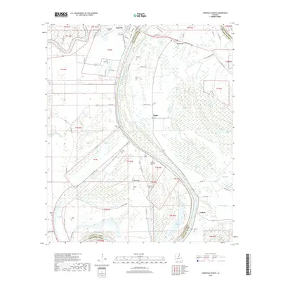
2018 Map of Jonesville South
USGS Topo · Published 2018About this map
The Black River serves as the dominant geographic spine of this river delta landscape, defining the winding boundary between Catahoula Parish and Concordia Parish. Near the confluence of the Little River and the Black, the town of Jonesville sits at a strategic junction of waterways and roads like Taylor St and Front St. This region is defined by its complex hydrography, where countless oxbows and swampy depressions like Gin Slough, Simpson Brake, and California Bayou illustrate the shifting nature of the alluvial plain.
Find a feature on this map
87 named features on this map. Tap any name to fly to it.
Don’t see what you’re looking for? This feature index may not catch every label — zoom into the map to look around manually.
Map Details
Editions of this 2018 Jonesville South Map
This is the sole edition of this map. No revisions or reprints were ever made.
Other maps of this area

1935 · Tooleys
USGS Topo · 1:62,500

1939 · Red Gum
USGS Topo · 1:62,500

1939 · Deer Park
USGS Topo · 1:62,500

1941 · Manifest
USGS Topo · 1:62,500

1941 · Tooleys
USGS Topo · 1:62,500

1953 · Natchez
USGS Topo · 1:250,000

1956 · Natchez
USGS Topo · 1:250,000

1959 · Natchez
USGS Topo · 1:250,000

1960 · Jonesville
USGS Topo · 1:62,500
1960 · Eva
USGS Topo · 1:62,500