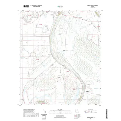
2020 Map of Jonesville South
USGS Topo · Published 2020About this map
The Black River and Little River converge at the northern edge of this landscape, framing the settlement of Jonesville. This region is defined by an intricate network of wetlands, sloughs, and brakes, where the meandering water creates distinct geographic features like Gin Slough, Snag Lake, and Simpson Brake. The landscape is heavily marked by family and plantation history, visible through numerous burial sites including Moss Grove Plantation Cem, Security Plantation Cem, and Griffin Cem. To the south and east, smaller communities like Wildsville, Security, and Lismore are connected by local routes such as Alice N Wonderland RD and Parish RD 5b-28. The presence of the Jonesville Airport near the confluence indicates the town's role as a local hub. The boundary between Catahoula Parish and Concordia Parish runs through these waterways, illustrating how the natural hydraulic patterns have historically dictated political borders in the Louisiana delta.
Find a feature on this map
93 named features on this map. Tap any name to fly to it.
Don’t see what you’re looking for? This feature index may not catch every label — zoom into the map to look around manually.
Map Details
Editions of this 2020 Jonesville South Map
This is the sole edition of this map. No revisions or reprints were ever made.
Other maps of this area

1935 · Tooleys
USGS Topo · 1:62,500

1939 · Red Gum
USGS Topo · 1:62,500

1939 · Deer Park
USGS Topo · 1:62,500

1941 · Manifest
USGS Topo · 1:62,500

1941 · Tooleys
USGS Topo · 1:62,500

1953 · Natchez
USGS Topo · 1:250,000

1956 · Natchez
USGS Topo · 1:250,000

1959 · Natchez
USGS Topo · 1:250,000

1960 · Jonesville
USGS Topo · 1:62,500
1960 · Eva
USGS Topo · 1:62,500