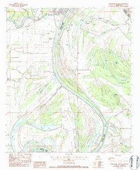
1983 Map of Jonesville South
USGS Topo · Published 1984About this map
The Black River dominates this landscape where Catahoula Parish and Concordia Parish meet, carving a wide path through a network of bayous and brakes. The river's influence is evident in the numerous oxbow lakes and sloughs, such as Gin Slough and Cauley Lake, which define the low-lying terrain south of Jonesville. Settlement is concentrated along the higher ground of the riverbanks and the Louisiana Midland rail line, with small communities like Wildsville and Omega established amidst the wetlands.
Find a feature on this map
71 named features on this map. Tap any name to fly to it.
Don’t see what you’re looking for? This feature index may not catch every label — zoom into the map to look around manually.
Map Details
Editions of this 1983 Jonesville South Map
This is the sole edition of this map. No revisions or reprints were ever made.
Other maps of this area

1935 · Tooleys
USGS Topo · 1:62,500

1939 · Red Gum
USGS Topo · 1:62,500

1939 · Deer Park
USGS Topo · 1:62,500

1941 · Manifest
USGS Topo · 1:62,500

1941 · Tooleys
USGS Topo · 1:62,500

1953 · Natchez
USGS Topo · 1:250,000

1956 · Natchez
USGS Topo · 1:250,000

1959 · Natchez
USGS Topo · 1:250,000

1960 · Jonesville
USGS Topo · 1:62,500
1960 · Eva
USGS Topo · 1:62,500