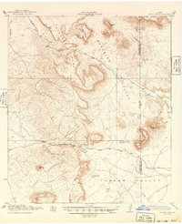
1930 Map of Jordan Gap
USGS Topo · Published 1949About this map
Jordan Gap and Puerto Potrillo serve as the primary topographical gateways through the high tablelands of Far West Texas, as documented in this survey conducted by R.B. Marshall and the Corps of Engineers. The landscape is dominated by massive flat-topped features like Antelope Mesa, Gemelo Mesa, and Whirlwind Mesa, which define the drainage patterns of Paradise Draw and Huckleberry Draw.
Find a feature on this map
25 named features on this map. Tap any name to fly to it.
Don’t see what you’re looking for? This feature index may not catch every label — zoom into the map to look around manually.
Map Details
Editions of this 1930 Jordan Gap Map
3 editions found
Other maps of this area

1895 · Marfa
USGS Topo · 1:125,000

1895 · Alpine
USGS Topo · 1:125,000

1896 · Shafter
USGS Topo · 1:125,000

1917 · Agua Fria
USGS Topo · 1:62,500

1917 · Tascotal Mesa
USGS Topo · 1:62,500

1917 · Buck Hill
USGS Topo · 1:62,500

1918 · Buck Hill
USGS Topo · 1:62,500

1918 · Jordan Gap
USGS Topo · 1:62,500

1925 · Buck Hill
USGS Topo · 1:62,500

1930 · Jordan Gap
USGS Topo · 1:62,500