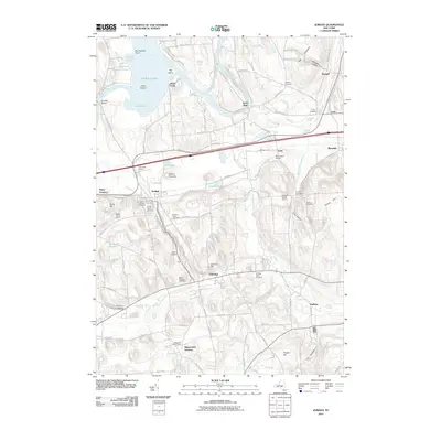
2011 Map of Jordan
USGS Topo · Published 2011About this map
The village of Jordan serves as a focal point for this landscape, where the historic path of the Erie Canal and the waters of Skaneateles Creek converge. The area’s agrarian character is well-preserved through markers like the Leubner Apple Farm and Plainville Farms, alongside numerous cemeteries that provide a deep record of local family history, including the Jordan Rural Cemetery and Saint Patricks Cemetery. To the north, the Seneca River flows toward Cross Lake, passing through the settlement of Jacks Reef. This terrain is dotted with small historical crossroads like Daboll Corners and Laird Corners, while industrial and logistical history is preserved at Skaneateles Junction and the Hart Lot Post Office. The inclusion of local aviation sites such as Anthonson Airport and Walls Airport illustrates how mid-20th-century infrastructure integrated with the traditional rural landscape.
Find a feature on this map
106 named features on this map. Tap any name to fly to it.
Don’t see what you’re looking for? This feature index may not catch every label — zoom into the map to look around manually.
Map Details
Editions of this 2011 Jordan Map
This is the sole edition of this map. No revisions or reprints were ever made.
Other maps of this area

1899 · Auburn
USGS Topo · 1:62,500

1899 · Skaneateles
USGS Topo · 1:62,500

1900 · Baldwinsville
USGS Topo · 1:62,500

1902 · Skaneateles
USGS Topo · 1:62,500

1902 · Weedsport
USGS Topo · 1:62,500

1902 · Auburn
USGS Topo · 1:62,500

1943 · Jordan
USGS Topo · 1:31,680

1943 · Lysander
USGS Topo · 1:31,680

1943 · Cato
USGS Topo · 1:31,680

1943 · Weedsport
USGS Topo · 1:31,680