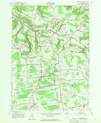
1943 Map of Jordanville
USGS Topo · Published 1970About this map
Holy Trinity Monastery stands as a spiritual anchor in this upland landscape of central New York during the early 1940s. The terrain is defined by a series of prominent rises including Shoemaker Hill, Rock Hill, and Harter Hill, which separate the drainage of Fulmer Creek from the southern headwaters of Oquionis Creek. The map documents a dense network of family-named cemeteries such as Henderson Cem, Piper Cem, and Helmer Cem, offering a valuable record for genealogical research in a region dominated by agricultural townships like German Flatts and Warren. Small rural centers such as Jordanville and Cullen are connected by winding roads like Earle Road and Ohyle Road, reflecting a settlement pattern that remained largely unchanged since the previous century. Landmarks like Days Rock and isolated structures such as School No 9 emphasize the localized nature of the community before the post-war expansion of regional infrastructure.
Find a feature on this map
42 named features on this map. Tap any name to fly to it.
Don’t see what you’re looking for? This feature index may not catch every label — zoom into the map to look around manually.
Map Details
Editions of this 1943 Jordanville Map
2 editions found
Other maps of this area

1898 · Utica
USGS Topo · 1:62,500

1900 · Little Falls
USGS Topo · 1:62,500

1900 · Utica
USGS Topo · 1:62,500

1903 · Richfield Springs
USGS Topo · 1:62,500

1903 · Little Falls
USGS Topo · 1:62,500

1907 · Winfield
USGS Topo · 1:62,500

1939 · Little Falls
USGS Topo · 1:62,500

1943 · Schuyler Lake
USGS Topo · 1:24,000

1943 · Jordanville
USGS Topo · 1:24,000

1943 · Richfield Springs
USGS Topo · 1:24,000