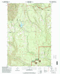
1995 Map of Jubilee Lake
USGS Topo · Published 1998About this map
Jubilee Lake serves as a central point of this high-elevation landscape where the boundaries of Umatilla, Union, and Wallowa counties converge. Located within the Umatilla National Forest, the map captures a topography defined by deep drainages and ridges, including Dusty Ridge and the headwaters of the Walla Walla River. The presence of the Spillway and Boat Ramp at the lake indicates its role as a managed recreation site amidst the surrounding wilderness areas.
Find a feature on this map
32 named features on this map. Tap any name to fly to it.
Don’t see what you’re looking for? This feature index may not catch every label — zoom into the map to look around manually.
Map Details
Editions of this 1995 Jubilee Lake Map
This is the sole edition of this map. No revisions or reprints were ever made.
Other maps of this area

1953 · Pendleton
USGS Topo · 1:250,000

1955 · Grangeville
USGS Topo · 1:250,000

1956 · Pendleton
USGS Topo · 1:250,000

1959 · Grangeville
USGS Topo · 1:250,000

1963 · Big Meadows
USGS Topo · 1:24,000

1963 · Andies Prairie
USGS Topo · 1:24,000

1963 · Tollgate
USGS Topo · 1:24,000

1964 · Partridge Creek
USGS Topo · 1:24,000

1964 · Rondowa
USGS Topo · 1:24,000

1967 · Fry Meadow
USGS Topo · 1:24,000