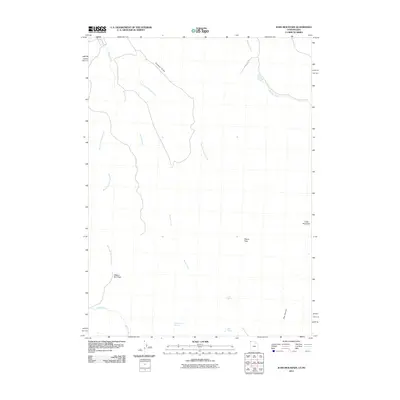
2011 Map of Judd Mountain
USGS Topo · Published 2011About this map
Judd Mountain rises over a high-desert landscape in the remote northeast corner of Box Elder County, where seasonal drainages and essential water sources dictate the geography. The map documents a network of hydrologic features including Triple Group Springs, Cold Spring, and Rock Spring, which provided critical watering points in this arid region of the Utah-Nevada borderlands. Transport through the high country is channeled by narrow corridors such as Wagon Box Pass and Deans Pass, with the latter served by the only named thoroughfare on the sheet, Dean Pass Rd. The complex drainage system is clearly defined by the diverging paths of Spring Creek and its many tributaries, alongside the prominent Gamble Draw and Big Canyon. This 2011 survey serves as a precise record of the natural landmarks and topographic breaks that have long guided movement across this sparsely inhabited terrain.
Find a feature on this map
14 named features on this map. Tap any name to fly to it.
Don’t see what you’re looking for? This feature index may not catch every label — zoom into the map to look around manually.
Map Details
Editions of this 2011 Judd Mountain Map
This is the sole edition of this map. No revisions or reprints were ever made.
Other maps of this area

1954 · Brigham City
USGS Topo · 1:250,000

1955 · Wells
USGS Topo · 1:250,000

1958 · Wells
USGS Topo · 1:250,000

1958 · Brigham City
USGS Topo · 1:250,000

1959 · Cotton Thomas Basin
USGS Topo · 1:62,500

1961 · Wells
USGS Topo · 1:250,000

1961 · Goose Creek
USGS Topo · 1:62,500

1961 · Dairy Valley
USGS Topo · 1:62,500

1962 · Brigham City
USGS Topo · 1:250,000
1971 · Grouse Creek
USGS Topo · 1:24,000