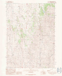
1989 Map of Judd Mountain
USGS Topo · Published 1989About this map
Judd Mountain stands at the heart of this high-desert landscape along the border of Utah and Nevada. The terrain is defined by a series of deep drainages and strategic crossings, including the prominent Wagon Box Pass in the southwest and Deans Pass toward the east. These passes served as critical passage points through the steep topography that separates the various creek systems. A complex network of watercourses, including Spring Creek and its many branches such as East Fork Spring Creek, dissects the land, suggesting a region where seasonal water flow and topography dictated movement.
Find a feature on this map
12 named features on this map. Tap any name to fly to it.
Don’t see what you’re looking for? This feature index may not catch every label — zoom into the map to look around manually.
Map Details
Editions of this 1989 Judd Mountain Map
This is the sole edition of this map. No revisions or reprints were ever made.
Other maps of this area

1954 · Brigham City
USGS Topo · 1:250,000

1955 · Wells
USGS Topo · 1:250,000

1958 · Wells
USGS Topo · 1:250,000

1958 · Brigham City
USGS Topo · 1:250,000

1959 · Cotton Thomas Basin
USGS Topo · 1:62,500

1961 · Wells
USGS Topo · 1:250,000

1961 · Goose Creek
USGS Topo · 1:62,500

1961 · Dairy Valley
USGS Topo · 1:62,500

1962 · Brigham City
USGS Topo · 1:250,000
1971 · Grouse Creek
USGS Topo · 1:24,000