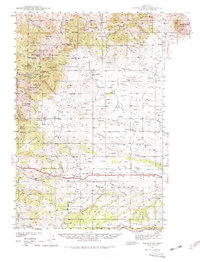
1941 Map of Judith Peak
USGS Topo · Published 1978About this map
The Ruins of Fort Maginnis and its associated Fort Maginnis Cem anchor the eastern slopes of the Judith Mountains, representing a transitional era in central Montana. This 1941 survey captures the waning mining pulse of the region, specifically around the settlements of Maiden and Giltedge. The landscape is heavily marked by industrial activity, with numerous entries such as the Spotted Horse Mine and the Giltedge Mine (inactive) illustrating the scale of gold and silver extraction that once dominated these peaks. Beyond the mines, the map details a developing rural infrastructure including the Great Northern Railroad corridor and several local schools like Cheadle Sch and Pleasant Plains Sch. This contrast between the high-altitude industrial sites like Judith Peak and the agricultural valley along Chippewa Creek provides a clear view of the diverse land use in Fergus County during the early 20th century.
Find a feature on this map
54 named features on this map. Tap any name to fly to it.
Don’t see what you’re looking for? This feature index may not catch every label — zoom into the map to look around manually.
Map Details
Editions of this 1941 Judith Peak Map
3 editions found
Other maps of this area

1889 · Big Snowy Mountain
USGS Topo · 1:250,000

1893 · Big Snowy Mountain
USGS Topo · 1:250,000

1941 · Lewistown
USGS Topo · 1:62,500

1941 · Judith Peak
USGS Topo · 1:62,500

1944 · Lewistown
USGS Topo · 1:62,500

1944 · Judith Peak
USGS Topo · 1:62,500

1954 · Roundup
USGS Topo · 1:250,000

1954 · Lewistown
USGS Topo · 1:250,000

1958 · Roundup
USGS Topo · 1:250,000

1959 · Lewistown
USGS Topo · 1:250,000