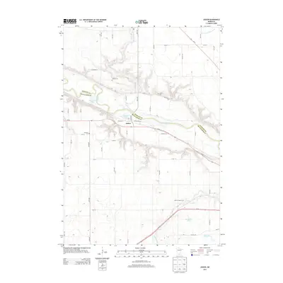
2013 Map of Judson
USGS Topo · Published 2013About this map
The Minnesota River carves a deep, winding valley through this landscape, serving as the natural boundary between Nicollet and Blue Earth counties. In the heart of the valley, the small settlement of Judson sits at a crossroads of rail and road, positioned between the river and the bluffs. This 2013 survey shows a region deeply rooted in its agricultural and immigrant history, evidenced by the high density of rural burial grounds scattered across the upland plateaus, including Jerusalem Cem, Hebron Cem, and Trinity Cem. The topography is defined by the sharp transition from flat agricultural fields to the intricate drainage ravines of Swan Lake Outlet and Minneopa Cr. To the south, Welsh Heritage Farms preserves the area's cultural ties, while small water bodies like McGibneys Lake and Horseshoe Lake occupy the river's flood plain.
Find a feature on this map
53 named features on this map. Tap any name to fly to it.
Don’t see what you’re looking for? This feature index may not catch every label — zoom into the map to look around manually.
Map Details
Editions of this 2013 Judson Map
This is the sole edition of this map. No revisions or reprints were ever made.
Other maps of this area

1951 · Mankato West
USGS Topo · 1:62,500

1953 · New Ulm
USGS Topo · 1:250,000

1957 · New Ulm
USGS Topo · 1:250,000

1958 · New Ulm
USGS Topo · 1:250,000

1964 · Courtland
USGS Topo · 1:24,000

1965 · North Star
USGS Topo · 1:24,000

1965 · Perth
USGS Topo · 1:24,000

1965 · Cambria
USGS Topo · 1:24,000
1965 · Nicollet
USGS Topo · 1:24,000

1967 · New Ulm
USGS Topo · 1:250,000