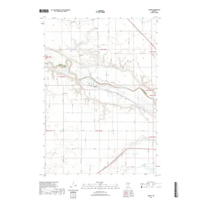
2019 Map of Judson
USGS Topo · Published 2019About this map
The Minnesota River carves a deep valley across this landscape, serving as the physical boundary between Nicollet and Blue Earth Counties. Centered in this riparian corridor is the unincorporated community of Judson, where Railroad St and local tracks parallel the river's course. The surrounding upland is defined by a dense concentration of early burial sites, including Jerusalem Cem, Hebron Cem, and Trinity Cem, which anchor the rural landscape and suggest the locations of early congregational centers.
Find a feature on this map
43 named features on this map. Tap any name to fly to it.
Don’t see what you’re looking for? This feature index may not catch every label — zoom into the map to look around manually.
Map Details
Editions of this 2019 Judson Map
This is the sole edition of this map. No revisions or reprints were ever made.
Other maps of this area

1951 · Mankato West
USGS Topo · 1:62,500

1953 · New Ulm
USGS Topo · 1:250,000

1957 · New Ulm
USGS Topo · 1:250,000

1958 · New Ulm
USGS Topo · 1:250,000

1964 · Courtland
USGS Topo · 1:24,000

1965 · North Star
USGS Topo · 1:24,000

1965 · Perth
USGS Topo · 1:24,000

1965 · Cambria
USGS Topo · 1:24,000
1965 · Nicollet
USGS Topo · 1:24,000

1967 · New Ulm
USGS Topo · 1:250,000