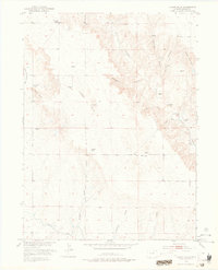
1951 Map of Judson Hills
USGS Topo · Published 1976About this map
The Sunnyside School stands as a quiet remnant of early educational infrastructure in this high plains region of northeastern Colorado, mapped during the early 1950s as part of the Missouri River Basin development project. The landscape is defined by its drainage network, where seasonal waterways like Wildcat Creek and Schaefer Draw carve through a series of prominent elevations including Minter Hill and Stony Point.
Find a feature on this map
19 named features on this map. Tap any name to fly to it.
Don’t see what you’re looking for? This feature index may not catch every label — zoom into the map to look around manually.
Map Details
Editions of this 1951 Judson Hills Map
3 editions found
Other maps of this area

1951 · Weldona
USGS Topo · 1:24,000

1951 · Orchard
USGS Topo · 1:24,000

1951 · Sunken Lake
USGS Topo · 1:24,000

1951 · Peace Valley School
USGS Topo · 1:24,000

1951 · Judson Hills
USGS Topo · 1:24,000

1951 · Fort Morgan
USGS Topo · 1:24,000

1954 · Sterling
USGS Topo · 1:250,000

1954 · Greeley
USGS Topo · 1:250,000

1957 · Greeley
USGS Topo · 1:250,000

1958 · Greeley
USGS Topo · 1:250,000