
1970 Map of Julia Lake
USGS Topo · Published 1990About this map
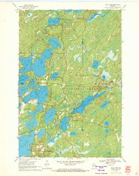
The Nicolet National Forest provides the setting for this detailed survey of the lake-heavy corridor between Three Lakes and Hiles. The landscape is dominated by an intricate aquatic network, where Big Fork Lake and Big Stone Lake are connected to smaller bodies like Medicine Lake and Deer Lake by natural channels. A notable feature is The Thoroughfare, a narrow passage linking Whitefish Lake and Virgin Lake, illustrating the historic water routes used by residents and early travelers.
Find a feature on this map
50 named features on this map. Tap any name to fly to it.
Don’t see what you’re looking for? This feature index may not catch every label — zoom into the map to look around manually.
Map Details
Editions of this 1970 Julia Lake Map
2 editions found
Historical Maps of Three Lakes Through Time
57 maps found

1930 Robbins
Oneida County, WI

1938 Lac Du Flambeau
Oneida County, WI

1938 Robbins
Oneida County, WI

1939 Cassian
Oneida County, WI

1939 Lac Du Flambeau
Oneida County, WI

1939 Mc Cord
Oneida County, WI

1940 Monico
Oneida County, WI

1942 Cassian
Oneida County, WI

1945 Robbins
Oneida County, WI

1946 Lac Du Flambeau
Oneida County, WI

1947 Mc Cord
Oneida County, WI

1950 Lac Du Flambeau
Oneida County, WI

1950 Monico
Oneida County, WI

1951 Lac Du Flambeau
Oneida County, WI

1965 Monico NE
Oneida County, WI

1965 Monico
Oneida County, WI

1965 Nashville
Oneida County, WI

1965 Starks
Oneida County, WI

1966 Heafford Junction
Oneida County, WI

1970 Dam Lake
Oneida County, WI
1970 Julia Lake
Oneida County, WI

1970 Sugar Camp
Oneida County, WI

1971 Bradley
Oneida County, WI

1971 Burrows Lake
Oneida County, WI

1971 Lac Du Flambeau SW
Oneida County, WI

1971 Mercer Lake
Oneida County, WI

1971 Pier Lake
Oneida County, WI

1971 Tripoli
Oneida County, WI

1982 George Lake
Oneida County, WI

1982 Harshaw
Oneida County, WI

1982 Hazelhurst
Oneida County, WI

1982 Heafford Junction
Oneida County, WI

1982 Lake Julia
Oneida County, WI

1982 Mc Naughton
Oneida County, WI

1982 Moen Lake
Oneida County, WI

1982 Woodboro
Oneida County, WI

2022 Bradley
Oneida County, WI

2022 Burrows Lake
Oneida County, WI

2022 Dam Lake
Oneida County, WI

2022 George Lake
Oneida County, WI

2022 Harshaw
Oneida County, WI

2022 Hazelhurst
Oneida County, WI

2022 Heafford Junction
Oneida County, WI

2022 Julia Lake
Oneida County, WI

2022 McNaughton
Oneida County, WI

2022 Mercer Lake
Oneida County, WI

2022 Moen Lake
Oneida County, WI

2022 Monico NE
Oneida County, WI

2022 Monico
Oneida County, WI

2022 Nashville
Oneida County, WI

2022 Pier Lake
Oneida County, WI

2022 Starks
Oneida County, WI

2022 Sugar Camp
Oneida County, WI

2022 Tripoli
Oneida County, WI

2022 Woodboro
Oneida County, WI

2023 Lac du Flambeau SW
Oneida County, WI

2023 Lake Julia
Oneida County, WI