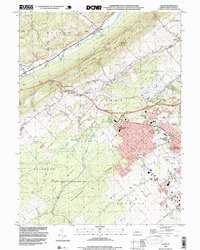
1994 Map of Julian
USGS Topo · Published 1999About this map
Bald Eagle Mountain divides the landscape here, separating the waters of Bald Eagle Creek in the northwest from the expanding urban footprint of State College to the southeast. During the mid-1990s, the rural character of communities like Julian and Matternville contrasted sharply with the suburban growth of Park Forest Village and Woodycrest. A significant portion of the western terrain is occupied by State Game Lands No 176, encompassing the unique scrublands known as The Barrens near the historic mining site at Scotia. This area reveals the transition from early industrial extraction and small family farms, marked by scattered burial grounds like Henderson Cem and Grays Cem, to a modern university-adjacent residential hub. Long-standing local institutions such as Matternville Sch and Radio Park Sch anchor these shifting community centers.
Find a feature on this map
41 named features on this map. Tap any name to fly to it.
Don’t see what you’re looking for? This feature index may not catch every label — zoom into the map to look around manually.
Map Details
Editions of this 1994 Julian Map
This is the sole edition of this map. No revisions or reprints were ever made.
Other maps of this area

1908 · Bellefonte
USGS Topo · 1:62,500

1909 · Bellefonte
USGS Topo · 1:62,500

1919 · Menno
USGS Topo · 1:62,500

1922 · Philipsburg
USGS Topo · 1:62,500

1923 · Tyrone
USGS Topo · 1:62,500

1929 · Tyrone
USGS Topo · 1:48,000

1933 · Tyrone
USGS Topo · 1:62,500

1935 · Allensville
USGS Topo · 1:62,500

1938 · Allensville
USGS Topo · 1:62,500

1939 · Philipsburg
USGS Topo · 1:62,500