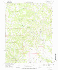
1979 Map of Jump Creek
USGS Topo · Published 1983About this map
Swisher Mine stands as a primary industrial marker in this high-altitude landscape of Carbon County, Utah, where resource extraction and rugged terrain intersect. The network of canyons, including Coal Canyon and Miller Canyon, highlights the region's historical reliance on coal mining and spring-fed water systems. Deep within the Manti-La Sal National Forest, the topography is defined by prominent high-ground features like Telephone Bench and Cedar Bench, which provided vantage points for early infrastructure. Natural drainage patterns are dominated by Jump Creek and the North Fork Gordon Creek, tracing paths through a series of gulches and breaks. Numerous unnamed prospects and mines are scattered across the slopes, indicating a period of intense geological exploration. The presence of a Pipeline and various Jeep Trails underscores the ongoing efforts to manage and extract resources from this remote mountain territory during the late 1970s.
Find a feature on this map
23 named features on this map. Tap any name to fly to it.
Don’t see what you’re looking for? This feature index may not catch every label — zoom into the map to look around manually.
Map Details
Editions of this 1979 Jump Creek Map
This is the sole edition of this map. No revisions or reprints were ever made.
Other maps of this area

1885 · Manti
USGS Topo · 1:250,000

1886 · Price River
USGS Topo · 1:250,000

1895 · Manti
USGS Topo · 1:250,000

1896 · Price River
USGS Topo · 1:250,000

1914 · Castle Gate
USGS Topo · 1:62,500

1916 · Castle Gate
USGS Topo · 1:62,500

1923 · Scofield
USGS Topo · 1:62,500

1925 · Scofield
USGS Topo · 1:62,500

1939 · Soldier Summit
USGS Topo · 1:62,500

1942 · Soldier Summit
USGS Topo · 1:62,500