2005 Map of Jump River Fire Tower NW
USGS Topo · Published 2006About this map
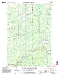
The Jump River and its numerous tributaries dominate this landscape in north-central Wisconsin, where the boundaries of Rusk, Price, and Taylor counties converge. Much of the southern and eastern portion of the map is defined by the Chequamegon-Nicolet National Forest, showcasing a region defined by complex hydrology and forest management. The network of water includes the Little Jump River, Main Fork Creek, and the North River, which meet amidst a series of Rapids. Settlement is sparse, with large townships like Hawkins and Kennan encompassing vast tracts of woodland and marsh. Local infrastructure is represented by rural connectors like Morgan Creek Road and Big Falls Road, while small-scale resource extraction is noted by a Gravel Pit near the river banks.
Find a feature on this map
25 named features on this map. Tap any name to fly to it.
Don’t see what you’re looking for? This feature index may not catch every label — zoom into the map to look around manually.
Map Details
Editions of this 2005 Jump River Fire Tower NW Map
This is the sole edition of this map. No revisions or reprints were ever made.
Other maps of this area

1941 · Kennan
USGS Topo · 1:48,000

1945 · Kennan
USGS Topo · 1:48,000

1945 · Black River
USGS Topo · 1:48,000

1945 · Ingram
USGS Topo · 1:48,000

1947 · Ingram
USGS Topo · 1:48,000

1947 · Sheldon
USGS Topo · 1:48,000

1949 · Sheldon
USGS Topo · 1:48,000

1949 · Jump River Fire Tower
USGS Topo · 1:48,000

1953 · Rice Lake
USGS Topo · 1:250,000

1959 · Rice Lake
USGS Topo · 1:250,000