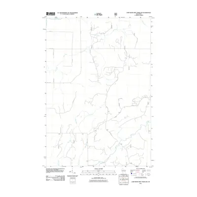
2011 Map of Jump River Fire Tower SW
USGS Topo · Published 2011About this map
The Jump River and Yellow River anchor the drainage of this Taylor County landscape, where the northern Wisconsin woodlands are etched by an extensive network of forestry and county roads. In the early 21st century, the terrain is characterized by its numerous small tributaries like Bear Creek, Weasel Creek, and Levitt Creek, which wind through the Chequamegon-Nicolet National Forest region. This network of thoroughfares, including County Hwy-D and Hannibal Rd, reveals a modern timber and recreational landscape managed through a grid of numbered routes like Forest Rd 113 and Forest Rd 1529. These routes, along with Forest Trail 304, indicate a territory used primarily for forestry management and outdoor access, preserving the character of the north woods in a time of established conservation and resource mapping.
Find a feature on this map
28 named features on this map. Tap any name to fly to it.
Don’t see what you’re looking for? This feature index may not catch every label — zoom into the map to look around manually.
Map Details
Editions of this 2011 Jump River Fire Tower SW Map
This is the sole edition of this map. No revisions or reprints were ever made.
Other maps of this area

1945 · Black River
USGS Topo · 1:48,000

1947 · Sheldon
USGS Topo · 1:48,000

1949 · Sheldon
USGS Topo · 1:48,000

1949 · Jump River Fire Tower
USGS Topo · 1:48,000

1951 · Lublin
USGS Topo · 1:48,000

1951 · Gilman
USGS Topo · 1:62,500

1953 · Rice Lake
USGS Topo · 1:250,000

1959 · Rice Lake
USGS Topo · 1:250,000

1969 · Perkinstown
USGS Topo · 1:24,000
1969 · Lublin NW
USGS Topo · 1:24,000