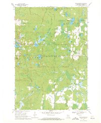
1969 Map of Perkinstown
USGS Topo · Published 1971About this map
The town of Perkinstown serves as a small hub for this 1969 survey of north-central Wisconsin, where the heavy woods of the Chequamegon National Forest dominate the landscape. This area is defined by a complex network of glacial kettle lakes and wetlands, including Hulls Lake, Kathryn Lake, and the remote Lake Nineteen. The presence of the Perkinstown Lookout Tower and a Radio Tower indicate the higher elevations used for forest management and communication during this era.
Find a feature on this map
42 named features on this map. Tap any name to fly to it.
Don’t see what you’re looking for? This feature index may not catch every label — zoom into the map to look around manually.
Map Details
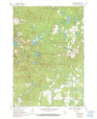
Editions of this 1969 Perkinstown Map
3 editions found

Other maps of this area

1944 · Ogema
USGS Topo · 1:48,000

1945 · Black River
USGS Topo · 1:48,000

1947 · Ogema
USGS Topo · 1:48,000
1949 · Ogema
USGS Topo · 1:48,000

1949 · Jump River Fire Tower
USGS Topo · 1:48,000

1951 · Lublin
USGS Topo · 1:48,000

1951 · Medford
USGS Topo · 1:48,000

1953 · Rice Lake
USGS Topo · 1:250,000

1959 · Rice Lake
USGS Topo · 1:250,000
1969 · Medford SW
USGS Topo · 1:24,000