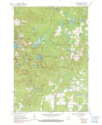
1969 Map of Perkinstown
USGS Topo · Published 1990About this map
Perkinstown and its surrounding woodlands are preserved here in a 1969 field check of Taylor County, highlighting a landscape defined by glacial kettle lakes and the dense timber of the Chequamegon National Forest. The settlement serves as a central hub for the township of Grover, situated near the Perkinstown Cem and the recreational waters of Kathryn Lake. The terrain is characterized by a high density of named water bodies, including Lake Nineteen, Richter Lake, and Anderson Lake, which are part of a complex drainage network feeding into the Black River and the South Fork Yellow River. This era shows the developed recreation at Kathryn Lake Campground alongside industrial traces like several Gravel Pits, illustrating the dual role of the forest as both a managed resource and a public wilderness. Significant township boundaries for Molitor and Hammel are also clearly delineated.
Find a feature on this map
37 named features on this map. Tap any name to fly to it.
Don’t see what you’re looking for? This feature index may not catch every label — zoom into the map to look around manually.
Map Details
Editions of this 1969 Perkinstown Map
3 editions found
Other maps of this area

1944 · Ogema
USGS Topo · 1:48,000

1945 · Black River
USGS Topo · 1:48,000

1947 · Ogema
USGS Topo · 1:48,000
1949 · Ogema
USGS Topo · 1:48,000

1949 · Jump River Fire Tower
USGS Topo · 1:48,000

1951 · Lublin
USGS Topo · 1:48,000

1951 · Medford
USGS Topo · 1:48,000

1953 · Rice Lake
USGS Topo · 1:250,000

1959 · Rice Lake
USGS Topo · 1:250,000
1969 · Perkinstown
USGS Topo · 1:24,000