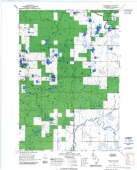
1969 Map of Perkinstown
USGS Topo · Published 1992About this map
Perkinstown sits at the heart of this Northwoods landscape, serving as a focal point for the surrounding Chequamegon National Forest. The map documents a transition in land use during the late 1960s, where traditional forestry and fire lookouts like the Perkinstown Lookout and the Foss Lake Forest Service Station coexist with emerging recreational interests. The complex glacial topography is evident in the dense concentration of kettle lakes such as Lake Eleven, Hulls Lake, and Richter Lake. Conservation and leisure are prioritized through the Ice Age National Scenic Trail and the Kathryn Lake Campground and Picnic Area. This period shows a deliberate management of the forest, including the designation of the Semi-Primitive Nonmotorized Area and the winding Perkinstown Motorized Trail, reflecting the dual nature of wilderness preservation and active outdoor recreation in Taylor County.
Find a feature on this map
45 named features on this map. Tap any name to fly to it.
Don’t see what you’re looking for? This feature index may not catch every label — zoom into the map to look around manually.
Map Details
Editions of this 1969 Perkinstown Map
3 editions found
Other maps of this area

1944 · Ogema
USGS Topo · 1:48,000

1945 · Black River
USGS Topo · 1:48,000

1947 · Ogema
USGS Topo · 1:48,000

1949 · Ogema
USGS Topo · 1:48,000

1949 · Jump River Fire Tower
USGS Topo · 1:48,000

1951 · Lublin
USGS Topo · 1:48,000

1951 · Medford
USGS Topo · 1:48,000

1953 · Rice Lake
USGS Topo · 1:250,000

1959 · Rice Lake
USGS Topo · 1:250,000

1969 · Perkinstown
USGS Topo · 1:24,000