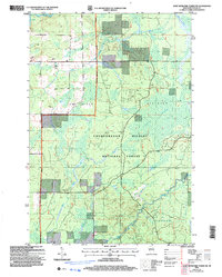
2005 Map of Jump River Fire Tower SW
USGS Topo · Published 2006About this map
Chequamegon Nicolet National Forest dominates this Taylor County landscape, reflecting the long-term management of the Medford - Park Falls Ranger District. The map captures a topography defined by drainage networks and wetland complexes, most notably the expansive Kidby Swamp. Water is a constant presence, with the Jump River and its accompanying rapids flowing through the northern reaches, while the Yellow River meanders across the southern sections near the borders of Cleveland and Grover. Local industry and infrastructure are represented by scattered Gravel Pits and a network of Forest Service roads. Small tributaries like Leavitt Creek and Bear Creek further delineate the township boundaries of Jump River and Westboro, providing a detailed look at the rural land divisions and natural waterways during the early 21st century.
Find a feature on this map
14 named features on this map. Tap any name to fly to it.
Don’t see what you’re looking for? This feature index may not catch every label — zoom into the map to look around manually.
Map Details
Editions of this 2005 Jump River Fire Tower SW Map
This is the sole edition of this map. No revisions or reprints were ever made.
Other maps of this area

1945 · Black River
USGS Topo · 1:48,000

1947 · Sheldon
USGS Topo · 1:48,000

1949 · Sheldon
USGS Topo · 1:48,000

1949 · Jump River Fire Tower
USGS Topo · 1:48,000

1951 · Lublin
USGS Topo · 1:48,000

1951 · Gilman
USGS Topo · 1:62,500

1953 · Rice Lake
USGS Topo · 1:250,000

1959 · Rice Lake
USGS Topo · 1:250,000

1969 · Perkinstown
USGS Topo · 1:24,000
1969 · Lublin NW
USGS Topo · 1:24,000