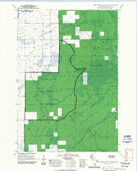
1970 Map of Jump River Fire Tower SW
USGS Topo · Published 1992About this map
Chequamegon National Forest dominates this northern Wisconsin landscape, where the Medford Ranger District manages a complex network of wetlands and protected woodlands. The terrain is defined by the Bear Creek Semi-Primitive Non-Motorized Area, a designation that preserves the quiet character of the forest. The drainage patterns are clearly marked by the winding courses of Levitt Creek, Wolf Creek, and Weasel Creek, which feed into the larger river systems.
Find a feature on this map
16 named features on this map. Tap any name to fly to it.
Don’t see what you’re looking for? This feature index may not catch every label — zoom into the map to look around manually.
Map Details
Editions of this 1970 Jump River Fire Tower SW Map
2 editions found
Other maps of this area

1945 · Black River
USGS Topo · 1:48,000

1947 · Sheldon
USGS Topo · 1:48,000

1949 · Sheldon
USGS Topo · 1:48,000

1949 · Jump River Fire Tower
USGS Topo · 1:48,000

1951 · Lublin
USGS Topo · 1:48,000

1951 · Gilman
USGS Topo · 1:62,500

1953 · Rice Lake
USGS Topo · 1:250,000

1959 · Rice Lake
USGS Topo · 1:250,000

1969 · Perkinstown
USGS Topo · 1:24,000
1969 · Lublin NW
USGS Topo · 1:24,000