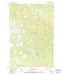
1979 Map of Wood Lake
USGS Topo · Published 1991About this map
Glacial wetlands and timberlands define this landscape along the border of Taylor and Lincoln counties. The central focus is Wood Lake, surrounded by a complex network of marshes and smaller water bodies like Mud Lake and the Camp Eight Flowage. The drainage pattern is intricate, with Johnson Creek, New Wood Creek, and Shea Creek cutting through the terrain. A notable historical layer is visible in the various transportation remnants that traverse the townships of Rib Lake and Corning. The presence of an Old RR Gr and another Old Railroad Grade suggests a history of resource extraction, likely logging, which once dominated this part of northern Wisconsin. These former rail lines now sit among scattered gravel pits and rural routes like Wood Creek Avenue, reflecting a transition from industrial timber hauling to a more quiet, recreation-oriented landscape.
Find a feature on this map
19 named features on this map. Tap any name to fly to it.
Don’t see what you’re looking for? This feature index may not catch every label — zoom into the map to look around manually.
Map Details
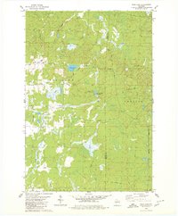
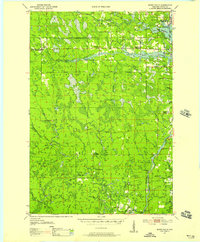
Editions of this 1979 Wood Lake Map
2 editions found
Other maps of this area

1902 · Marathon
USGS Topo · 1:125,000

1945 · Rib Lake
USGS Topo · 1:48,000

1947 · Rib Lake
USGS Topo · 1:48,000

1949 · Rib Lake
USGS Topo · 1:48,000
1950 · Spirit Falls
USGS Topo · 1:48,000

1951 · Athens
USGS Topo · 1:48,000

1951 · Hamburg
USGS Topo · 1:48,000

1952 · Spirit Falls
USGS Topo · 1:48,000

1953 · Rice Lake
USGS Topo · 1:250,000

1954 · Iron Mountain
USGS Topo · 1:250,000