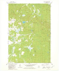
1979 Map of Wood Lake
USGS Topo · Published 1980About this map
Glacial topography and timber history define this 1970s landscape on the border of Taylor and Lincoln Counties. The terrain is dominated by a complex network of wetlands and drainage, including Wood Lake, Mud Lake, and the expansive Camp Eight Flowage. The map documents a rural transition where the logging infrastructure of the past is still visible in the form of several Old Railroad Grade segments and the Old RR GR stretching across the north. These remnants of the railroad era parallel modern township developments, such as the grids near Wood Creek Avenue.
Find a feature on this map
18 named features on this map. Tap any name to fly to it.
Don’t see what you’re looking for? This feature index may not catch every label — zoom into the map to look around manually.
Map Details
Editions of this 1979 Wood Lake Map
2 editions found
Other maps of this area

1902 · Marathon
USGS Topo · 1:125,000

1945 · Rib Lake
USGS Topo · 1:48,000

1947 · Rib Lake
USGS Topo · 1:48,000

1949 · Rib Lake
USGS Topo · 1:48,000

1950 · Spirit Falls
USGS Topo · 1:48,000

1951 · Athens
USGS Topo · 1:48,000

1951 · Hamburg
USGS Topo · 1:48,000

1952 · Spirit Falls
USGS Topo · 1:48,000

1953 · Rice Lake
USGS Topo · 1:250,000

1954 · Iron Mountain
USGS Topo · 1:250,000