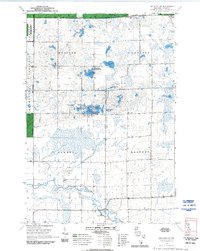
1970 Map of Medford NW
USGS Topo · Published 1992About this map
The Chequamegon National Forest dominates this northern Wisconsin landscape, where the Mondeaux Dam Ranger District meets the Medford Ranger District. The terrain is defined by a dense concentration of glacial kettle lakes, including Sackett Lake and the Washington Flowage. Local history is anchored by the Molitor Cem and the Brookside Sch, reflecting the sparse but established rural community within the townships of Molitor, Chelsea, Hammel, and Medford. Waterways such as the Black River and the North Fork Yellow River drain the marshy lowlands between numerous gravel pits. Family-named landmarks like Matt Ochs Lake and small crossroads like Murat provide valuable points of reference for genealogists tracing ancestral landholdings in Taylor County.
Find a feature on this map
37 named features on this map. Tap any name to fly to it.
Don’t see what you’re looking for? This feature index may not catch every label — zoom into the map to look around manually.
Map Details
Editions of this 1970 Medford NW Map
2 editions found
Other maps of this area

1944 · Ogema
USGS Topo · 1:48,000

1945 · Black River
USGS Topo · 1:48,000

1947 · Ogema
USGS Topo · 1:48,000

1949 · Ogema
USGS Topo · 1:48,000

1949 · Jump River Fire Tower
USGS Topo · 1:48,000

1951 · Lublin
USGS Topo · 1:48,000

1951 · Medford
USGS Topo · 1:48,000

1953 · Rice Lake
USGS Topo · 1:250,000

1959 · Rice Lake
USGS Topo · 1:250,000

1969 · Perkinstown
USGS Topo · 1:24,000