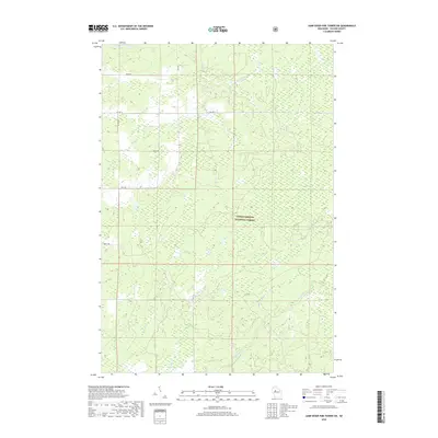
2018 Map of Jump River Fire Tower SW
USGS Topo · Published 2018About this map
Chequamegon-National Forest dominates this section of Taylor County, where the dense woodlands of northern Wisconsin are defined by a complex network of glacial hydrology. The Yellow River flows through the southern half of the quadrangle, joined by tributaries like Weasel Cr and Bear Cr that drain the forested interior. In the north, Levitt Cr winds through the landscape, while the sprawling Kidrick Swamp illustrates the region's wetland character. Human presence is marked by a grid of rural forest roads, including Co Hwy D, Miller Dr, and Berry Dr, which provide access through the timberlands. This 2018 survey reveals a landscape largely dedicated to conservation and natural resource management, where the drainage patterns of small creeks continue to shape the forest floor.
Find a feature on this map
13 named features on this map. Tap any name to fly to it.
Don’t see what you’re looking for? This feature index may not catch every label — zoom into the map to look around manually.
Map Details
Editions of this 2018 Jump River Fire Tower SW Map
This is the sole edition of this map. No revisions or reprints were ever made.
Other maps of this area

1945 · Black River
USGS Topo · 1:48,000

1947 · Sheldon
USGS Topo · 1:48,000

1949 · Sheldon
USGS Topo · 1:48,000

1949 · Jump River Fire Tower
USGS Topo · 1:48,000

1951 · Lublin
USGS Topo · 1:48,000

1951 · Gilman
USGS Topo · 1:62,500

1953 · Rice Lake
USGS Topo · 1:250,000

1959 · Rice Lake
USGS Topo · 1:250,000

1969 · Perkinstown
USGS Topo · 1:24,000
1969 · Lublin NW
USGS Topo · 1:24,000