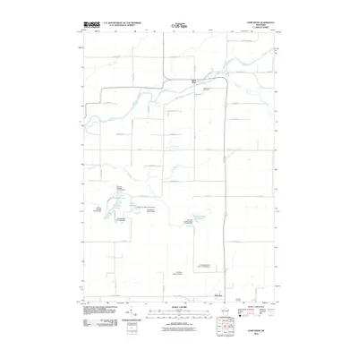
2010 Map of Jump River
USGS Topo · Published 2010About this map
Jump River and Hannibal serve as the primary focal points of this Taylor County landscape, where managed waterways and rural roads define the settlement patterns. The eponymous Jump River flows through the northern reaches, while the southern terrain is marked by the presence of the Fisher River. Significant water management is evident through a series of engineered flowages and dams, including the Monson Flowage, Holzer Flowage, and Waterfowl Flowage. These features, along with the Pershing Wildlife Area, suggest a landscape heavily utilized for conservation and flood control. For those tracing local families, Mount Nebo Cemetery and Hannibal Cemetery provide critical genealogical anchors. The grid of local routes like County HWY-MM and Bridge DR connects isolated farmsteads and residential clusters, reflecting a late-20th-century rural infrastructure preserved in this 2010 record.
Find a feature on this map
50 named features on this map. Tap any name to fly to it.
Don’t see what you’re looking for? This feature index may not catch every label — zoom into the map to look around manually.
Map Details
Editions of this 2010 Jump River Map
This is the sole edition of this map. No revisions or reprints were ever made.
Other maps of this area

1945 · Black River
USGS Topo · 1:48,000

1947 · Sheldon
USGS Topo · 1:48,000

1949 · Sheldon
USGS Topo · 1:48,000

1949 · Jump River Fire Tower
USGS Topo · 1:48,000

1951 · Lublin
USGS Topo · 1:48,000

1951 · Gilman
USGS Topo · 1:62,500

1953 · Rice Lake
USGS Topo · 1:250,000

1959 · Rice Lake
USGS Topo · 1:250,000
1969 · Lublin NW
USGS Topo · 1:24,000
1970 · Jump River Fire Tower NW
USGS Topo · 1:24,000