
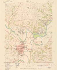
1950 Map of Junction City
USGS Topo · Published 1950About this map
Junction City sits at the strategic confluence of the Republican River and the Smoky Hill River, forming the headwaters of the Kansas River. This mid-century view reveals a landscape heavily shaped by its proximity to the Fort Riley Military Reservation, which dominates the northern half of the sheet. The infrastructure of the era is evident in the dense street grid of the city, which houses critical community landmarks like the Court house, the Kansas Gas and Electric Company, and schools such as Franklin High School.
Find a feature on this map
74 named features on this map. Tap any name to fly to it.
Don’t see what you’re looking for? This feature index may not catch every label — zoom into the map to look around manually.
Map Details
Editions of this 1950 Junction City Map
2 editions found
Other maps of this area

1886 · Junction City
USGS Topo · 1:125,000

1889 · Junction City
USGS Topo · 1:125,000

1889 · Parkerville
USGS Topo · 1:125,000

1894 · Junction City
USGS Topo · 1:125,000

1894 · Parkerville
USGS Topo · 1:125,000

1947 · Manhattan
USGS Topo · 1:62,500

1947 · Fort Riley
USGS Topo · 1:62,500

1950 · Keats
USGS Topo · 1:24,000

1950 · Alida
USGS Topo · 1:24,000

1951 · Ogden
USGS Topo · 1:24,000