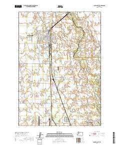
2020 Map of Junction City
USGS Topo · Published 2020About this map
Junction City and northern Eugene anchor this Willamette Valley landscape, where the flat agricultural plains meet the winding course of the Willamette River. The river's complexity is on display through a series of braided channels and named features like Harpers Bend, Marshall Island, and Bells Shute Bar. This 2020 survey captures the transition from town grids to rural acreage, punctuated by a series of aviation facilities including Munson Airport, Strauch Field, and the large Mahlon Sweet Field. For genealogists and local historians, the presence of the Milliron Cem and Luper Cem provides specific points of interest among the network of farm-to-market roads. The Burlington Northern Santa Fe railroad corridor cuts a straight line through the valley, highlighting the enduring importance of this transportation spine in Oregon's heartland.
Find a feature on this map
100 named features on this map. Tap any name to fly to it.
Don’t see what you’re looking for? This feature index may not catch every label — zoom into the map to look around manually.
Map Details
Editions of this 2020 Junction City Map
This is the sole edition of this map. No revisions or reprints were ever made.
Other maps of this area

1909 · Harrisburg
USGS Topo · 1:31,680

1909 · Rowland
USGS Topo · 1:31,680

1909 · Elmira
USGS Topo · 1:62,500

1910 · Eugene
USGS Topo · 1:62,500

1911 · Monroe
USGS Topo · 1:31,680

1912 · Halsey
USGS Topo · 1:62,500

1922 · Monroe
USGS Topo · 1:62,500

1922 · Elmira
USGS Topo · 1:62,500

1939 · Monroe
USGS Topo · 1:62,500

1940 · Eugene
USGS Topo · 1:62,500