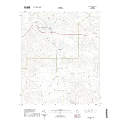
2020 Map of Junction City
USGS Topo · Published 2020About this map
Junction City serves as a focal point in this section of West Central Georgia, situated near the confluence of the Talbot, Taylor, and Marion county lines. The landscape is defined by its water system, where Patsiliga Cr and Whitewater Cr drain through a series of significant local impoundments including Watson Millpond, Parks Millpond, and Carl Brown Lake. These water features, alongside smaller creeks like Black Cr and Shoal Cr, suggest a history of agricultural and timber reliance.
Find a feature on this map
86 named features on this map. Tap any name to fly to it.
Don’t see what you’re looking for? This feature index may not catch every label — zoom into the map to look around manually.
Map Details
Editions of this 2020 Junction City Map
This is the sole edition of this map. No revisions or reprints were ever made.
Other maps of this area

1907 · Talbotton
USGS Topo · 1:125,000

1950 · Talbotton
USGS Topo · 1:24,000

1950 · Geneva
USGS Topo · 1:24,000

1950 · Buena Vista NE
USGS Topo · 1:24,000

1950 · Buena Vista
USGS Topo · 1:62,500

1950 · Talbotton
USGS Topo · 1:62,500

1955 · Talbotton
USGS Topo · 1:24,000

1955 · Buena Vista NE
USGS Topo · 1:24,000
1955 · Geneva
USGS Topo · 1:24,000
1955 · Talbotton
USGS Topo · 1:62,500